Category:Forest fires
Jump to navigation
Jump to search
Subcategories
This category has the following 11 subcategories, out of 11 total.
Media in category "Forest fires"
The following 110 files are in this category, out of 110 total.
-
 "יער התבערה"- זעקת העצים שנשרפו מטרור העפיפונים מגבול עזה.jpg 1,306 × 1,080; 300 KB
-
 028 longleaf-burn.jpg 480 × 321; 37 KB
-
 13990412000723637293101648422710 17171 آتش سوزی جنگلهای پاوه.jpg 1,050 × 639; 170 KB
-
 13990412000723637293101762455577 94353 آتش سوزی جنگلهای پاوه.jpg 1,050 × 636; 186 KB
-
 1588765748598 0S6A5735.jpg 1,920 × 1,280; 1.43 MB
-
 2014-365-291 Fried By the Lake (15582050262).jpg 5,184 × 3,456; 7.03 MB
-
 20160802-FS-Shoshone-KH-012 (42396563515).jpg 5,184 × 3,456; 19.05 MB
-
 20180930 FS BTNF CJC DozerOperations RooseveltFire 1.jpg 4,032 × 3,024; 2.7 MB
-
 20180930 FS BTNF CJC DozerOperations RooseveltFire 2.jpg 2,906 × 2,227; 1,011 KB
-
 208 Brulega arbaro.svg 512 × 512; 3 KB
-
 A forest fire 1950 (JOKAMT2On17-2).tif 5,393 × 3,444; 53.17 MB
-
 ABTF - Auto Bomba Tanque Florestal.jpg 1,000 × 667; 251 KB
-
 Aerial photo of fire in Chernobyl Exclusion Zone, 2018.jpg 1,280 × 720; 51 KB
-
 Amazon fire satellite image.png 6,969 × 5,846; 28.28 MB
-
 An-32P, Chernobyl Exclusion Zone, 2018.jpg 800 × 533; 32 KB
-
 AS09-22-3379 (21846673940).jpg 4,400 × 4,600; 1.45 MB
-
 AS09-22-3380 (21846988088).jpg 4,400 × 4,600; 1.44 MB
-
 AS09-22-3381 (21847931749).jpg 4,400 × 4,600; 1.42 MB
-
 Athabasca ice fields.jpg 4,608 × 3,456; 6.86 MB
-
 August 2007 forest fire in Istria (2).JPG 2,288 × 1,712; 637 KB
-
 BAT-2 & MAZ fire engine, Chernobyl Exclusion Zone, 2020.jpg 1,280 × 960; 193 KB
-
 BAT-2, Chernobyl Exclusion Zone, 2020.jpg 1,280 × 853; 216 KB
-
 Baugh Creek after Sharps fire.jpg 960 × 720; 193 KB
-
 Björnnäset naturreservat - bränd skog.jpg 4,032 × 3,024; 6.77 MB
-
 Björnnäset naturreservat - naturvårdsbränning.jpg 4,032 × 3,024; 6.16 MB
-
 Björnnäset naturreservat - snö på bränd trädstam.jpg 4,032 × 3,024; 2.92 MB
-
 Bosbewerking, takken, struiken, branden, Bestanddeelnr 251-9175.jpg 2,580 × 2,702; 1.34 MB
-
 Burnt Pine Forest Salgi Himachal Jul19 D72 11268.jpg 5,446 × 3,631; 20.17 MB
-
 Burnt Pine Trees PLT-TR-FT-12.jpg 3,872 × 2,592; 10.54 MB
-
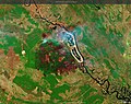
 Canada amo 2011135 lrg.jpg 3,000 × 3,800; 2.76 MB
-
 Cascades Regrowth after forest fire.jpg 4,032 × 3,024; 5.61 MB
-
 Chernobyl Exclusion Zone Rosoha Forest fire, 2020-04-13.jpg 960 × 540; 34 KB
-
 Chornobyl forest fire, 12.04.2020-sp.jpg 960 × 540; 26 KB
-
 Chornobyl forest fire, 2020.jpg 945 × 707; 50 KB
-
 Christy Clark fire season 2015.jpg 5,472 × 3,648; 6.97 MB
-
 Copernicus Sentinel-2 maps Chernobyl fire.gif 1,755 × 1,273; 4.51 MB
-
 Edge of the great fire of 1926 - Flickr - pellaea.jpg 3,648 × 2,493; 3.95 MB
-
Einfluss der Eisschmelze auf die Waldbrandgefahr.webm 56 s, 1,920 × 1,080; 49.32 MB
-
 Fade To Red Firewatch (140977673).jpeg 2,048 × 1,345; 639 KB
-
 Fire at Shirley Hills.jpg 4,099 × 2,306; 7.62 MB
-
 Fire engine, Chernobyl Exclusion Zone, 2020.jpg 1,080 × 810; 78 KB
-
 Fire engines, Chernobyl Exclusion Zone, 2020-04-09.jpg 960 × 720; 100 KB
-
 Fire engines, Chernobyl Exclusion Zone, 2020.jpg 960 × 720; 178 KB
-
 Forest Fire (28116663140).jpg 2,972 × 2,352; 1.87 MB
-

-
 Forest fire in Oleiros, Portugal.jpg 3,507 × 2,480; 5.42 MB
-
 Forest fire.jpg 1,200 × 674; 472 KB
-
 Forest Firefighter (28320623011).jpg 2,239 × 2,795; 1.46 MB
-
 Forest fires in Nepal impact air quality.jpg 4,001 × 2,541; 2.25 MB
-
 Forest fires.jpg 4,608 × 3,456; 5 MB
-
 Forestfires.png 565 × 405; 17 KB
-
 Forestfires2.png 564 × 386; 27 KB
-
 Gorse Fire in Killarney National Park.jpg 1,440 × 2,160; 728 KB
-
 GreatSlaveLake NASA Canada AMOA2004204 lrg.jpg 1,400 × 919; 485 KB
-
 Henri IV highway in Quebec City 30 May 2010 during the forest fires.jpg 3,504 × 2,336; 3.09 MB
-
 IMR, Chernobyl Exclusion Zone, 2020 01.jpg 720 × 960; 90 KB
-
 IMR, Chernobyl Exclusion Zone, 2020 02.jpg 720 × 960; 106 KB
-
 IMR, Chernobyl Exclusion Zone, 2020 03.jpg 720 × 960; 140 KB
-
 IMR, Chernobyl Exclusion Zone, 2020 04.jpg 959 × 640; 126 KB
-
 Incendi forestal a Sogorb, febrer de 2014.JPG 4,479 × 2,994; 1.09 MB
-
 Incendie de Landiras 16 juillet 2022.jpg 3,024 × 4,032; 1.45 MB
-
 Incendio en RBSM.jpg 1,280 × 960; 651 KB
-
 Incendio forestal en Puente Sampayo (28871071456).jpg 2,000 × 1,333; 535 KB
-

-
 Man holding a lecture to people using the bulletin board.jpg 3,504 × 2,336; 421 KB
-
 Manavgatyangını2021(çolaklı).jpg 6,000 × 8,000; 14.42 MB
-
 Matollar cremat a Collserola - 20210502 190049.jpg 4,128 × 3,096; 3.24 MB
-
 Matollar cremat a Collserola - 20210502 190252.jpg 4,128 × 3,096; 5.05 MB
-
 Matollar cremat a Collserola - P1300974.jpg 3,264 × 2,448; 3.96 MB
-
 Mil Mi-8, Chernobyl Exclusion Zone, 2020 01.jpg 960 × 720; 74 KB
-
 Mil Mi-8, Chernobyl Exclusion Zone, 2020.jpg 960 × 720; 22 KB
-

-
 Niger, Dantchandou, cleared tiger bush.jpg 3,264 × 2,448; 3.78 MB
-
 Post Forest Fire.jpg 2,160 × 1,440; 670 KB
-
 Požár Hůrek ve filmu Jan Cimbura.png 1,213 × 929; 694 KB
-
 Roads and uncontrolled fire, threats to Western Ghats, A.J.T.Johnsingh.jpg 3,648 × 2,736; 7 MB
-
 Robert kemp collection image Aircraft Water bomber.jpg 715 × 900; 148 KB
-
 Rowantree Grain, Howcleuch Forest - geograph.org.uk - 686444.jpg 640 × 488; 240 KB
-
 School Kids During Forest Fire.jpg 5,169 × 3,347; 3.48 MB
-
 Sentinel-2 L2A Custom script.jpg 9,930 × 7,832; 15.55 MB
-
 Skogbrann sivilforsvaret.jpg 720 × 960; 124 KB
-
 Start of a forest fire? (3649021140).jpg 2,272 × 1,704; 827 KB
-
 The Path To The Scenic Caves (3011293947).jpg 1,024 × 765; 278 KB
-
 Total Area Burned for All Fire Types, 2015 (48008921963).jpg 3,030 × 2,426; 841 KB
-
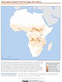
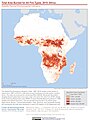 Total Area Burned for All Fire Types, 2015 Africa (48008921828).jpg 2,359 × 3,154; 769 KB
-
 Total Area Burned for All Fire Types, 2015 Asia (48008915251).jpg 2,419 × 3,154; 807 KB
-
 Total Area Burned for All Fire Types, 2015 Europe (48008921793).jpg 2,425 × 3,154; 737 KB
-
 Total Area Burned for All Fire Types, 2015 North America (48009002812).jpg 2,425 × 3,154; 746 KB
-
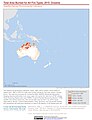 Total Area Burned for All Fire Types, 2015 Oceania (48009003012).jpg 2,409 × 3,154; 634 KB
-
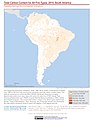
 Total Area Burned for All Fire Types, 2015 South America (48009002797).jpg 2,423 × 3,154; 702 KB
-
 Total Carbon Content for All Fire Types, 2015 (48008921863).jpg 3,027 × 2,382; 782 KB
-
 Total Carbon Content for All Fire Types, 2015 Africa (48009003007).jpg 2,357 × 3,154; 725 KB
-
 Total Carbon Content for All Fire Types, 2015 Asia (48008915146).jpg 2,419 × 3,154; 794 KB
-
 Total Carbon Content for All Fire Types, 2015 Europe (48008914911).jpg 2,425 × 3,154; 722 KB
-
 Total Carbon Content for All Fire Types, 2015 North America (48008914876).jpg 2,425 × 3,154; 740 KB
-
 Total Carbon Content for All Fire Types, 2015 Oceania (48008915076).jpg 2,409 × 3,154; 629 KB
-
 Total Carbon Content for All Fire Types, 2015 South America (48009002697).jpg 2,423 × 3,154; 678 KB
-

-
 Umpqua National Forest Fires, 2017 (40790608695).jpg 5,472 × 3,648; 6.42 MB
-
 Water bomber in Thunder Bay.jpg 800 × 600; 74 KB
-
Wie entstehen Feuerwolken?.webm 55 s, 1,920 × 1,080; 51.73 MB
-
 Zona forestal quemada autopista Itata.jpg 4,032 × 1,816; 3.29 MB
-
 Ветерниците и пожарот на планина Карабалија меѓу Богданци и Дојран.jpg 4,288 × 3,216; 259 KB
-
 Ветерниците и пожарот на планина Карабалија, Богданци.jpg 4,288 × 3,216; 258 KB
-
 Вид на лесной пожар - panoramio.jpg 3,840 × 2,160; 645 KB
-
 Вход в Нижний мир.jpg 3,024 × 4,032; 6.67 MB
-
 Пожежі в лісах ЧАЕС.webp 1,536 × 1,086; 171 KB
-
 Сказки братьев Гримм 2.jpg 3,024 × 4,032; 4.66 MB
-
 Сказки братьев Гримм.jpg 4,032 × 3,024; 3.23 MB
-
 آتشسوزی باغهای سُرخه 13990324000591637276593009961910 91623 PhotoT.jpg 1,050 × 639; 222 KB


.jpg)
.jpg)


.jpg)
.jpg)
.jpg)

.JPG)


.jpeg)


.jpg)
.jpg)


.jpg)


.jpg)
.jpg)

.jpg)


.jpg)


.jpg)
.jpg)
.jpg)
.jpg)
.jpg)
.jpg)
.jpg)
.jpg)
.jpg)
.jpg)
.jpg)
.jpg)
.jpg)
.jpg)
.jpg)
.jpg)
.jpg)


.jpg)